


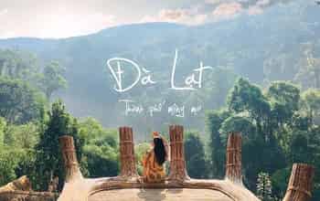
Sa Mu Peak: A Heavenly Paradise Where One Visit Is Never Enough

Sa Mu - U Bò Peak Beckons Trekkers with Breathtaking Cloud Seas, Mysterious Primeval Forests, and the Grandeur of Vietnam's Northwest.
Untamed Beauty and a Challenging Journey
Sa Mu Peak - U Bo, commonly known as Sa Mu, stands at over 2,700m and is located on the border between Son La and Yen Bai provinces. In the past year, Sa Mu has become the most frequently conquered peak among the 17 mountains in the Northwest region.
The stunning beauty and diverse forest ecosystem, especially the enchanting mossy forest, along with its streams, waterfalls, and picturesque photo spots, have continuously drawn trekkers to conquer Sa Mu on 2-day, 1-night expeditions.
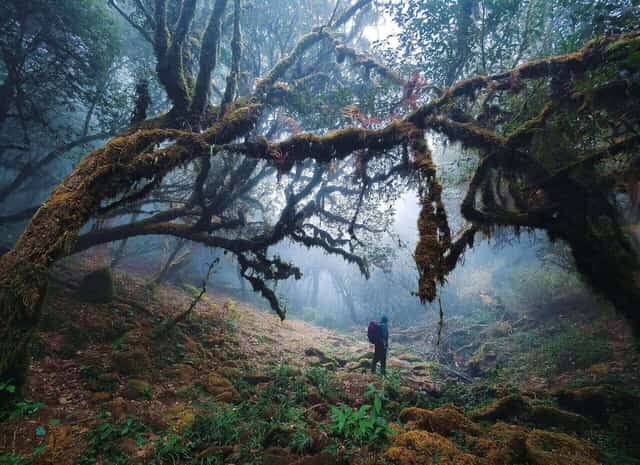
Photo: Nguyen Trong Cung
To conquer this peak, if you're starting from Hanoi, you'll need to travel over 200 km to Ta Xua commune (Bac Yen district, Son La province), and then continue another 20 km to the trekking starting point. The most common option for trekkers is to rent a car or take a bus from My Dinh bus station the evening before, stay overnight in Ta Xua, and begin the climb the following day.
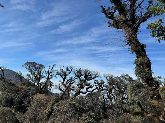
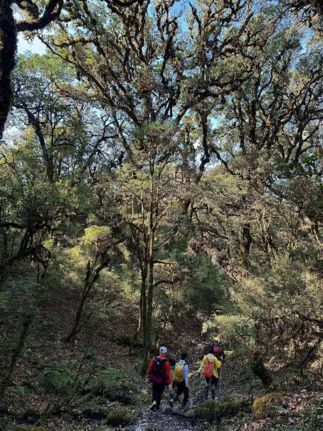
Photo: Duc Hung
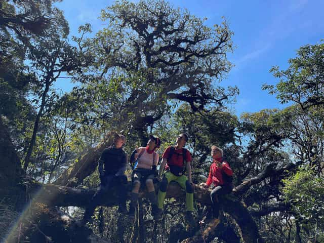
The Sa Mu trekking route, with a total length of 15-20 km depending on the descent path, winds through a pristine forest rich in diverse flora such as moss, rhododendrons, maple leaves, bamboo forests, and numerous streams and waterfalls.
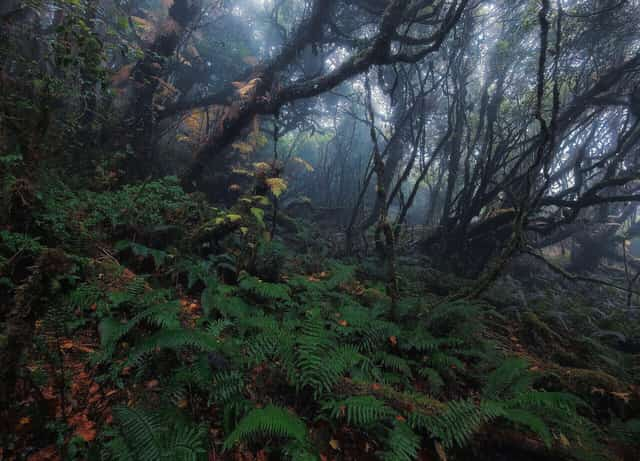
Photo: Nguyen Trong Cung
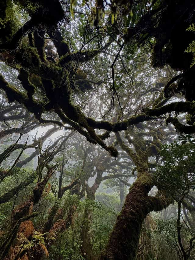
Photo: Duc Hung
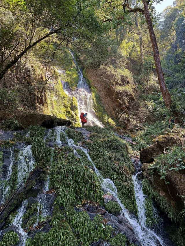
This two-tiered waterfall is locally known as Monkey Waterfall (Thac Khi) because many monkeys used to gather in this area - Photo: Duc Hung
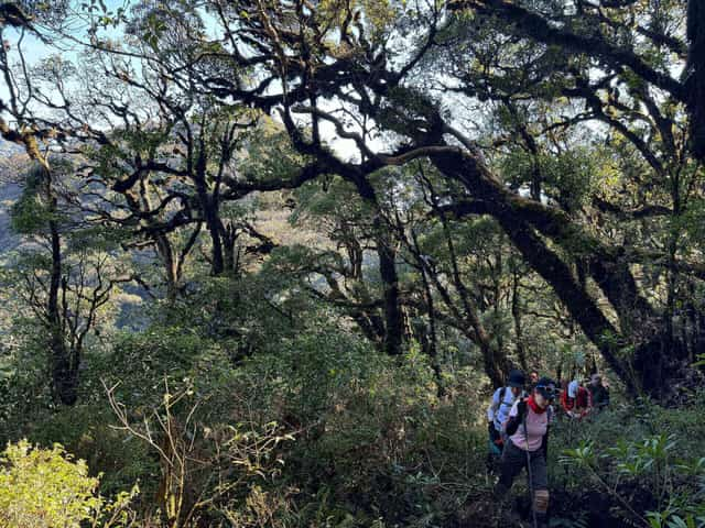
Photo: Duc Hung
The path from the base of the mountain to the campsite near the summit isn't overly steep, winding through small streams and an ancient forest with leaning, twisted trees. As you ascend, the climate and vegetation change, with thick moss covering the trails and coating large, strangely shaped trees from root to canopy.
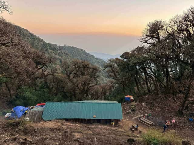
The campsite, with a capacity for 60-70 people, is located on a relatively flat area and was built by local residents in December 2022 - Photo: Duc Hung
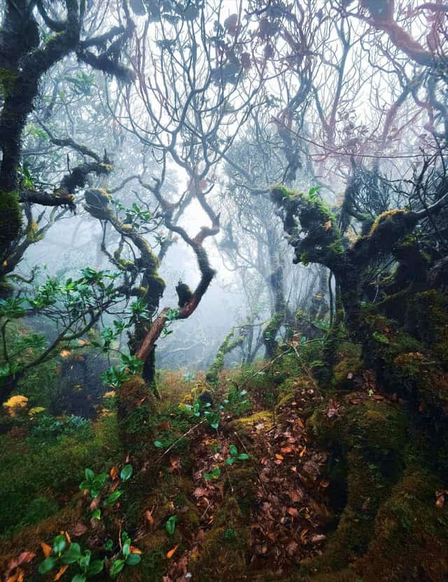
Photo: Nguyen Trong Cung
“Sa Mu is a beautiful peak, home to the largest mossy forest in the Northwest, and also a paradise of clouds. What makes it special is the variety of ascent and descent routes, offering different levels of difficulty, so trekkers of varying fitness levels can all enjoy the climb. That's why it has held the top spot as the most climbed peak for over a year now,” shared Mr. Manh Chien, administrator of the Mountain Climbing Enthusiasts Association, a forum with over 120,000 members.
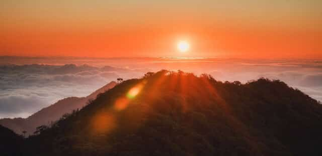
Sunrise on Sa Mu Peak - Photo: Duc Hung
To accommodate the growing number of trekkers, three additional small shelters were built last year not far from the main campsite. However, on weekends, these are still often insufficient, as sometimes 250-300 trekkers arrive to conquer Sa Mu Peak.
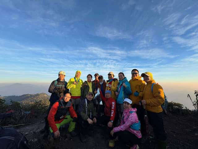
The author's climbing group takes a commemorative photo with the stainless steel summit marker on Sa Mu Peak
According to A Cho, a local guide and porter, trekkers should plan their Sa Mu climb on weekdays to avoid overcrowding, which can lead to a lack of available shelters or inconvenience for daily activities and taking photos at popular check-in spots, including the stainless steel marker at the summit.
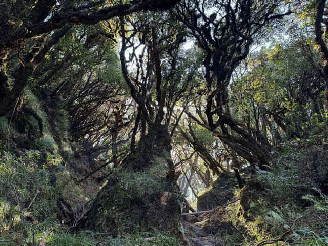
Photo: Duc Hung
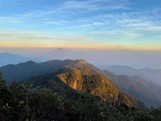
Sa Mu Peak is one of only four peaks in the Northwest where trekkers can enjoy both sunset on the first day and sunrise the following morning, thanks to the campsite's proximity to the summit.
Sunset on Sa Mu Peak - Photo: Nguyen Van Truong
Sa Mu is one of five high peaks in the Northwest (including Ta Chi Nhu, Lao Than, Ngu Chi Son, and Lung Cung) that offers a 360-degree panoramic view from its open, treeless summit. From Sa Mu Peak, you can see other famous mountains like Ta Xua and Ta Chi Nhu.
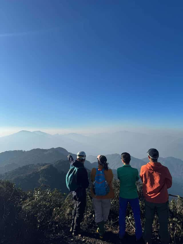
Photo: Duc Hung
The best time to climb Sa Mu is from September to April of the following year, when the weather is cool and there's no forest rain. Particularly from September to November, the changing colors of maple leaves create a poetic landscape, and from March to April, rhododendron flowers bloom vibrantly across Sa Mu's slopes.
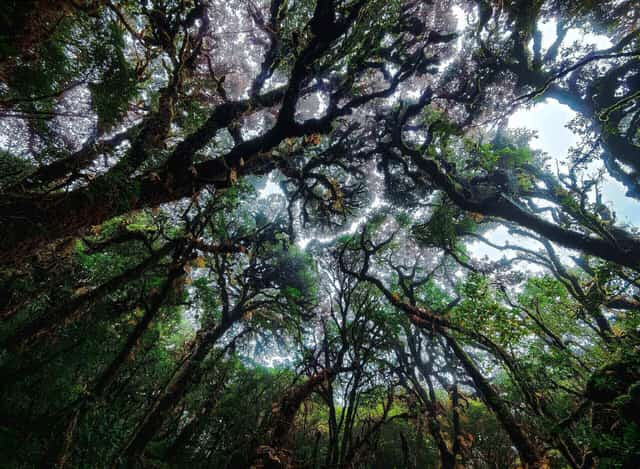
Photo: Nguyen Trong Cung
There are several descent routes from Sa Mu Peak, but the most scenic one, often chosen by trekkers, leads down towards Hang Dong commune. This route is about 14 km long and passes through the largest and most enchanting moss-covered primeval forest in the Northwest. This is truly a highlight of the Sa Mu trek.
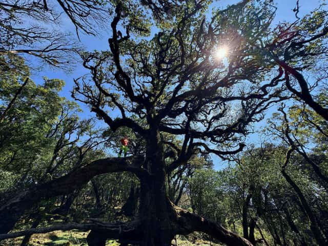
Photo: Duc Hung
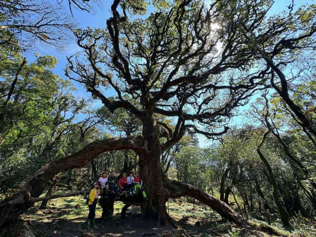
Check-in at the giant spider tree - Photo: Duc Hung
The 'spider tree' or 'gnarled tree,' with its roots bulging out on both sides, resembles a giant spider and is the most photographed check-in spot on the Sa Mu trekking route. This tree is located on the path towards Hang Dong commune and also serves as a lunch stop on the second day.
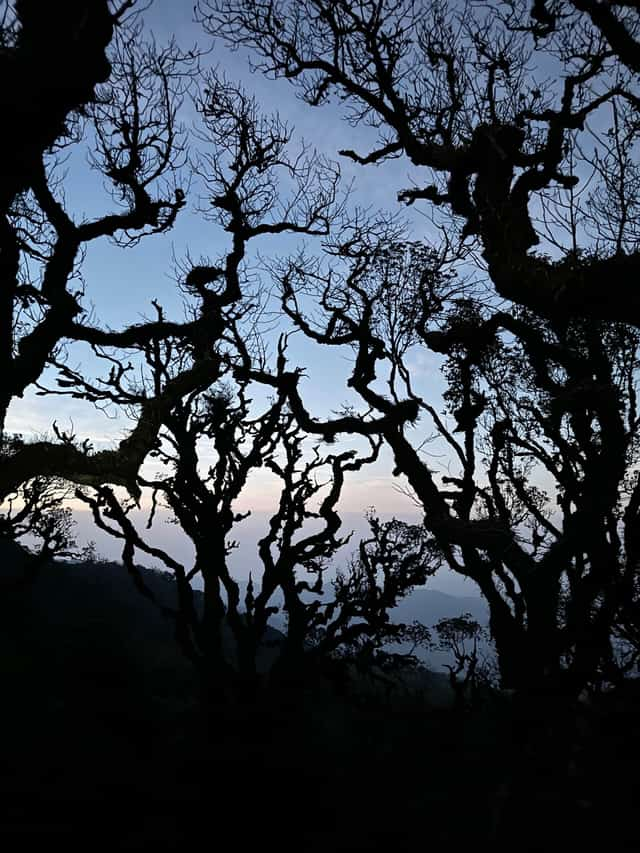
Photo: Duc Hung
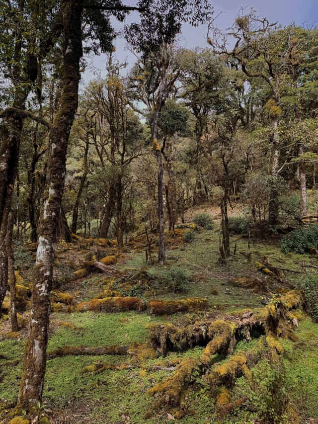
Photo: Manh Chien
“I've climbed many peaks, but when I set foot on Sa Mu, I was overwhelmed by the beauty of its primeval forest, with numerous ancient trees of unique shapes covered in enchanting moss. Sa Mu is a peak where one visit is never enough,” shared Mr. Nguyen Trong Cung, a passionate mountaineer and photographer.
In Son La, visitors can also explore many other historical sites, such as:
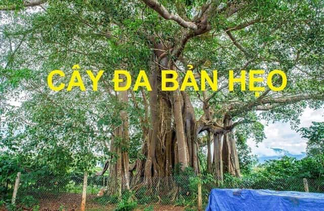
1. BAN HEO BANYAN TREE
The Party Cell chose the Ban Heo banyan tree as a secret communication point with revolutionary bases outside the prison and with the Party Central Committee. In 1942-1943, as the revolutionary situation both domestically and internationally underwent many changes, the Party Central Committee directed the Yen Bai and Phu Tho bases to establish a communication line with the Son La Prison Party Cell.View details
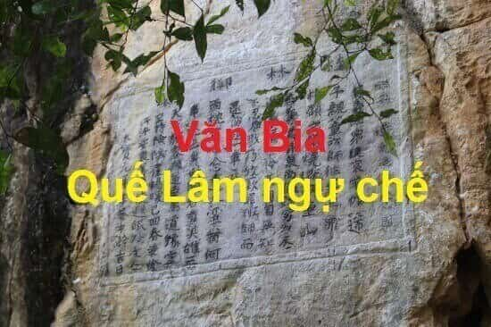
2. Que Lam Ngu Che Stele
The historical relic of Que Lam Ngu Che Stele is located in Group 3, Chieng Le Ward, Son La City. This site bears witness to the historical period when the talented and strategic King Le Thai Tong, along with his soldiers, campaigned against rebellious forces in the western border region of the country, ensuring peace for the nation. The relic was classified as a National-level historical site by the Ministry of Culture and Information on February 5, 1994.View details
3. Thuan Chau Flag Tower Historical Site
The Thuan Chau Flag Tower Historical Site is located in Pan village, Chieng Ly commune, Thuan Chau district. This site marks a historical event on May 7, 1959, when President Ho Chi Minh, along with the Party and Government leadership, visited the Northwest. During the resistance against the French and after peace was re-established in the North, despite being busy with countless national affairs, Uncle Ho – the beloved father of the nation – always showed concern for the ethnic people of the Northwest.View details
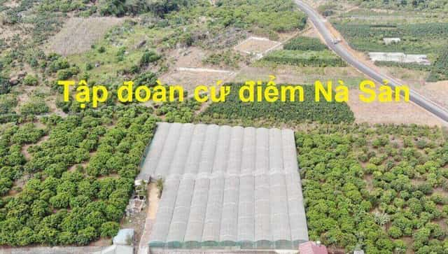
4. Na San Stronghold Historical Site
The Na San Stronghold is located on the Na San plateau, a basin within Chieng Mun commune - Mai Son district - Son La province, covering an area of about 10km2 and surrounded by mountains over 700m high. It featured an airfield, a command post, several outposts, a powerful artillery system with four 105mm cannons, and numerous trenches encircling and protecting the central area.View details
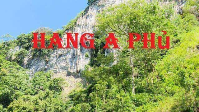
5. A Phu Cave
Tham Can Cave, also known as 'A Phu Couple Cave,' was Revolutionary Base 99 during Son La province's resistance against the French. The cave is located in Hong Ngai commune, Bac Yen district, Son La province. The historical site comprises two caves: The first cave (a dry cave) is situated at the foot of U Bo mountain, surrounded by a pristine forest with a fresh, cool climate.View details
Son La 7209 view
Update day : 13/04/2024
Source : Vietnamnet Affiliate links
Monuments close by
See all
Son La Prison Relics
Son La Prison was built by the French colonialists in 1908, next to Nam La stream on top of Khau Ca hill, now in To Hieu ward, Son La city, Son La province. This place held 1,007 communist prisoners, was a revolutionary school, and where the "red seeds" of the Vietnamese revolution were nurtured. Son La Prison was built by the French colonialists in 1908 with an initial area of 500 m2, mainly to imprison common criminals. In 1930, as the Vietnamese revolution's struggle for national independence increased, the French colonialists expanded Son La Prison by 1,500 m2 and began to detain political prisoners. In 1940, the French colonialists built a prison camp with an area of 170 square meters with the intention of holding female prisoners, but this plot was not carried out. Thus, through 3 times of construction and expansion, Son La Prison has a total area of 2,170 m2. In particular, during the process of expanding the prison, the French colonialists also built a series of underground cells 3 meters deep underground, hidden by the kitchen area above. The underground cell system includes 5 individual cells and 2 collective cells, including 1 dark cell. Son La Prison is solidly built, with walls made of stone and brick, and a roof of corrugated iron. The beds for prisoners are built of stone, have a cement surface, and have a leg shackle system along the length of the floor on the outside. With such a design, the Laotian winds of the Northwest region with blazing heat in the summer and cold frosts in the winter have caused diseases to arise and spread quickly. Son La prison is likened to "an open coffin, just waiting for the prisoner to die and bury him". From 1930 to 1945, the French colonialists exiled to Son La Prison 14 groups of political prisoners with a total of 1,013 prisoners, including many comrades who were members of the Central Committee, Party Committee, City Party Committee and many others. core Party officials. Faced with the crimes of the enemy, more than ever, the spirit of the communists shone and lit the fire of revolutionary struggle throughout the Northwest mountains and forests, greatly contributing to the success of the General War. August Uprising in 1945. This place has become a great revolutionary school, training and fostering for the Party and the Vietnamese revolution outstanding and typical Communist soldiers such as: To Hieu, Le Duan, Truong Chinh, Nguyen Luong Bang, Van Tien Dung, Le Duc Tho, Nguyen Van Tran, Le Thanh Nghi, Tran Quoc Hoang and other faithful comrades. With peace restored, Son La Provincial Museum has renovated and embellished the Prison relic three times in 1980, 1994, 2009 - 2010. Son La Prison historical relic also has 2 points: Ban Heo banyan tree, the contact point between Son La Prison Cell and the Party Central Committee and Son La Prison Martyrs Cemetery (Guava Root Cemetery) is The resting place of more than 60 heroes and martyrs who sacrificed their lives at Son La Prison. The historical site of Son La Prison has become a red address in the work of educating revolutionary traditions for generations of ethnic groups in Son La and the people of the whole country. Son La Prison was ranked national in 1962 and a special national historical site on December 31, 2014. Son La Prison Relics has become a school, a center of revolutionary traditional education for generations of Vietnamese people, especially the younger generation. Source: Son La Province Electronic Information Portal
Son La
8511 view
Rating : Special national monument

Thuan Chau Flag Tower historical site
Thuan Chau Flag Tower historical site is located in Pan village, Chieng Ly commune, Thuan Chau district. This place marks a historic event on May 7, 1959, when President Ho Chi Minh together with the Party and Government leadership visited the Northwest. During the resistance war against the French and after peace was restored in the North, despite being busy with thousands of national affairs, Uncle Ho, the beloved Father of the nation, always cared about the people of the Northwest ethnic groups. Responding to Uncle Ho's trust, the people of the Northwest ethnic groups were courageous in fighting, enthusiastically emulating productive labor and wished to welcome Uncle Ho to visit and report to him on his achievements. On May 7, 1959, the wishes of the people of the Northwest peoples came true. The square of the capital of the Thai autonomous region, Meo, was resplendent with flags, flowers, banners and slogans and more than 10,000 people representing 430,000 people from the Northwest ethnic groups happily welcomed Uncle Ho leading the Party and Government delegation. cover the visit. With an extremely simple, intimate and close gesture, Uncle Ho recognized and praised the sacrifices and enormous contributions of the people of the Northwest ethnic groups in the resistance war against the French colonialists and in restoring the economy. economy after the war. On behalf of the Government, he presented the people of the Northwest ethnic groups with the first-class Labor Medal. He advised: We must enthusiastically compete for economic and social development, strengthen economic sectors, apply science and technology to production, develop education and healthcare networks, and strengthen national security. room. More than 40 years have passed, and his advice has been persistently strived to be implemented by the Party Committee, government and people of Son La ethnic groups, and has been making great changes in the Western region of the country. big. Today, the Thuan Chau flag tower historical relic is located right on the campus of Thuan Chau district stadium. Source: Son La province electronic information portal
Son La
8396 view
Rating : National monument
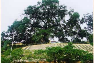
NAKED VERSION TREE
In the early twentieth century, the French colonialists established their governing apparatus in the Northwest region. They built Son La Prison to imprison, exile, and destroy the will to fight of revolutionary soldiers and patriotic Vietnamese people. In December 1939, political prisoners at the prison held a secret meeting and decided to establish a provisional cell. The cell chose the Heo banyan tree as a secret contact point with the revolutionary base outside the prison and with the Party Central Committee. In 1942 - 1943, the revolutionary situation in the country and the world was very volatile, the Party Central Committee directed the Yen Bai and Phu Tho base areas to establish a contact line with the Son La prison cell. Every day, political prisoners in Son La Prison had to go to the banyan tree area to get firewood, so the prisoners set up a secret mailbox to contact and assess the enemy situation, in order to organize an escape. According to the planned plan, in January 1943, Comrades at the Central Agency arranged to meet with comrades in Son La Prison Party Cell at Ban Heo banyan tree. Agree on the prison escape plan. With the careful preparation of prisoners from inside the prison to comrades and soldiers outside the prison, on August 3, 1943, the Cell successfully organized an escape for elite prisoners. returned to the Party Central Committee to continue revolutionary activities. Thus, during the period of struggle against the invading French colonialists, along with other communication locations, the Heo banyan tree was the place where the secret mailbox was located, and the meeting and communication place between communist soldiers of the Communist Party of Vietnam. The prison cell and the Central leadership - have really played an important role, contributing to creating a solid information network, covering the enemy's dense spy network, serving development. of the revolution and contributed greatly to the victory of the movement to gain power in Son La in particular and the country in general. The Heo banyan tree is now a revolutionary historical relic in the special national relic complex of Son La Prison, managed by the Provincial Museum. Every year, the monument welcomes hundreds of thousands of visitors to visit, learn and research. Even though it has gone through many ups and downs of history, the banyan tree is still there as a testament to a historical period of revolution in the twentieth century. Source: Son La Provincial Museum
Son La
8370 view
Rating : National monument

The Guilin Stele dominates
Que Lam Ngu Che stele historical relic belongs to group 3, Chieng Le ward, Son La city. This place demonstrates the historical period of the talented and great strategist Le Thai Tong and his soldiers conquering rebels in the western border region of the country, keeping peace for the country. The relic was ranked at the National level by the Ministry of Culture and Information on February 5, 1994. King Le Thai Tong, whose name is Nguyen Long, is the second son of King Le Thai To (Le Loi) and Queen Mother Pham Thi Ngoc Tran, a native of Quan Lai, Loi Duong district (now Tho Xuan - Thanh Hoa). ). Since ascending the throne, King Le Thai Tong has paid great attention to the Northwest region, the land of the country. To consolidate and ensure national unity, like King Le Thai To and other kings, during the 9 years of reigning the country, King Le Thai Tong twice commanded soldiers to go to the Northwest to suppress traitors. inverse. In March of the year Canh Than (1440), the king for the first time personally and with his soldiers went to the Western town to fight a rebel army named Thuong Nghiem in Chau Muong Muoi (now Thuan Chau district, Son La province). Wherever the king went, he was supported by the people, so the royal army quickly crushed the rebels. On the way back, the king and his soldiers stopped at Dong La (Tham Bao Ke), a natural rock cave in Muong La province. The king saw that this place had beautiful scenery, favorable geography, profound meaning and a peaceful soul. The king had his soldiers carve a poem and preface on the cliff at the entrance of Dong La. The poem, Guilin Ngu Che, has the following meaning: "The chief of Thuan Chau, Thuong Nghiem, rebelled, was ungrateful, and led his troops to follow the Ai Lao people to rebel. Personally commanded six armies to conquer it. Thuong Nghiem used all his strength and offered an elephant to surrender. I felt sorry for him for kneeling and crawling without a weapon, not having the heart to cut him, so I forgave him, then brought the army back and left a poem. Exactly one year later, in March 1441, the king again sent troops to suppress the Nghiem Nghiem rebellion in Chau Muong Muoi. Everywhere he went, the people responded and helped him, so the royal army quickly captured General Ai Lao. Dao Mong, at the same time captured Thuong Nghiem's children Sinh Tuong and Dong Dong. The traitor Thuong Nghiem surrendered and accepted the crime, from now on the western border of the Fatherland has been at peace. To pay tribute to the merits of King Le Thai Tong and to make the Que Lam Ngu Che stele monument forever dignified and shine in the hearts of successive generations, meeting the spiritual and healthy religious needs of a large number of people. people, with the consent of the Ministry of Culture and Information, in September 2001 the Provincial Party Committee and People's Committee of Son La started construction of the temple of King Le Thai Tong in Son La town and was inaugurated on September 22. January 2003, named "Guilin Ling Tu". Source: Son La province electronic information portal
Son La
8193 view
Rating : National monument

Ta Vai Bridge
Ta Vai Bridge, located in Ta Vai village, Chieng Hac commune, Yen Chau district, is a famous historical relic of the province. During the resistance war against the French colonialists, the bridge not only had a meaning for people's livelihood but was also a historical relic. Ta Vai village has a bridge with 46 fierce attacks and suffered 1,272 bombs from American aircraft to cut off the main artery of Highway 6. But the bridge still stands, ensuring smooth traffic. In 1965, the American enemy used air force and commandos to frantically sabotage the North in order to prevent the North from providing support to the Southern people. On June 20, 1965, American planes dropped 6 bombs on Khau Day village (Chieng Hac, Yen Chau) and 20 rockets on Ta Vai bridge. . Starting from here, American aircraft continuously bombarded Yen Chau, but due to good preparation of plans to deal with America's destructive war, Yen Chau entered the war without being surprised. At this time, Ta Vai bridge became a place of fierce fighting between us and the enemy. With the determination to ensure smooth traffic flow in all situations, determined to stay at the traffic center of Ta Vai bridge, the militia and self-defense force and armed force units have always stuck to the road and bridge to ensure traffic is clear. Here, from March to December 1966, we arranged the 14th Battalion of anti-aircraft artillery to protect the Ta Vai bridge, in which Company 3, consisting of two 37mm artillery batteries, was positioned in the area of Ban Tat hill. , adjacent to Tai Vai bridge, Company 2, consisting of four 37mm guns, was arranged in a continuous position to the west of Ta Vai bridge. In addition to the two main battlefields with 37 mm cannons, there is also a secondary battlefield consisting of a 12.7 mm company located in lower terrain also near Ta Vai bridge. To arrange such a battlefield, the people of Ta Vai village and the soldiers dug fortifications to build a road around the hillside to pull up artillery. Each 37 mm cannon required 200 people to pull it. To encourage morale and help soldiers fight, the people of Ta Vai village enthusiastically participated in the fighting and produced rice to contribute to the front lines. During those years, the people of Ta Vai, along with other villages in Chieng Hac commune, contributed nearly 9 tons of vegetables, 500kg of poultry, tons of food... In addition, the commune's performance team also went to the battlefield in uniform. army and militia service. Many times having to move the battlefield, the people and the soldiers used forest rope to braid to pull the artillery; used bamboo to make shacks for the soldiers and helped the soldiers dig over 3,000 meters of shelters on the battlefield with the determination to protect the transportation artery for the battlefield. The enemy destroyed bridges and roads, but the spirit of the army and people here was undeterred. Despite the roar of bombs and bullets, they still enthusiastically repaired the roads for vehicles to pass, with the emulation movement "Singing over the sound of bombs" and "Singing over the sound of bombs" and "Singing over the sound of bombs" The enemy broke it, I'll fix it. If the enemy destroys me, let me go." On December 8, 1966, the enemy organized 3 groups of planes to drop bombs on the hill where there was an anti-aircraft artillery battlefield and bombarded the Ta Vai bridge. At this time, 2 bridge spans were hit by bombs and fell into the stream and traffic on Route 6. was cut. Because the bridge was in a dangerous location, the stream was wide, the water was deep, and the enemy fought day and night, so it was very difficult to rebuild the bridge. Faced with that situation, the bridge protection unit decided to build a bypass and underground road to ensure traffic at all costs. The underground tunnel of Ta Vai bridge was built by soldiers and civilians about 1km downstream, but the enemy still discovered it and continued to bombard it. With courageous fighting spirit, the army and militia units have well secured traffic arteries. Promoting the tradition of tenacious fighting and the spirit of solidarity, the people of Ta Vai village with a boiling spirit of hatred for the invaders turned into revolutionary actions in combat and production, making an outstanding contribution to the achievements in defeating the US imperialist plot to expand the war. At the Ta Vai battlefield, the army and people of Yen Chau shot down 2 F105 planes and captured American enemy pilots with rifles, the lifeline of support for the South was always running smoothly, that victory quickly spread throughout the world. place, known throughout the country. Today, the war has receded into the past, the people of Ta Vai work hard in production and continue to contribute human and material resources to their homeland, where the Ta Vai bridge marks the crimes of American imperialism during the war. war of invasion in Vietnam. Talking about Ta Vai bridge is talking about the heroic, resilient fighting spirit and glorious fighting of Yen Chau's army and people. Source: Son La province electronic information portal
Son La
8107 view
Rating : Provincial level relics
Nearby tourist attractions
See all
Dai Yem Waterfall
In addition to the name Dai Yem, this waterfall is also called "Nang waterfall" or "Ban Vat waterfall". The waterfall originates from two streams of Bo Co Lam and Bo Ta Chau, located at the confluence of Vat stream and Bo Sap stream, in Muong Sang commune, Moc Chau district. Legend has it that more than 700 years ago, there was a couple who loved each other dearly. But because of the war, both had to separate. The boy went to war, and the girl went to the waterfall every day to wait for her lover to return. One day, it rained and stormed, the water flooded the entire waterfall. The girl was swept away, leaving only the token of love, an embroidered scarf, scattered near the waterfall. The villagers mourned so they named the waterfall "Dai Yem", which in ancient Thai means "Love Thread". Because of this touching legend, the waterfall has become a place to "prove love" and an ideal destination for many couples. Currently, the waterfall is being preserved and managed by Dai Yem Waterfall Tourist Area. Like a girl in the age of love, Dai Yem waterfall is sometimes gentle and peaceful but also sometimes fierce and passionate. To fully feel the wild beauty mixed with a bit of dreaminess of the waterfall, you should come here during the pouring water season. The period from April to September is the best time to see the falls. At this time, the stream flows rapidly, the amount of water pouring in is huge, creating a white, mesmerizing curtain, making viewers overwhelmed and excited. But if you want to see something gentler and quieter, you can also visit the waterfall in the dry season. At that time, the waterfall will become gentle and full of dreams. The sound of the gurgling stream mixed with the chirping of birds from the deep forest, all blend together, creating a poetic scene. But if you want to see something gentler and quieter, you can also visit the waterfall in the dry season. At that time, the waterfall will become gentle and full of dreams. The sound of the gurgling stream mixed with the chirping of birds from the deep forest, all blend together, creating a poetic scene. The first experience that any tourist cannot miss is admiring the majestic beauty of Dai Yem waterfall. The waterfall is more than 100m high, divided into two distinct branches: the upper waterfall is about 4,000 m2 wide with 9 floors symbolizing 9 levels of love, while the lower waterfall is smaller (area of about 300 m2) and has 3 floors. The two clusters of waterfalls are about 200m apart, flowing day and night. From a distance, they look like a soft peach band winding around the cliff. With its poetic and magical beauty, this waterfall has become a place to visit, picnic, check in and take photos for many tourists, especially young people.
Son La
7239 view
From January to December

Tien Phong Lake
Tien Phong Lake in Son La is a typical place of wild and majestic beauty, but extremely romantic in the Northwest mountains and forests. Visiting this land, visitors will admire the charming feng shui and enjoy the fresh air of nature, and have many interesting experiences when yachting on the lake. Located in the middle of the vast steppe, Tien Phong Lake has thousands of winds and warm sunshine, captivating many tourists. Tien Phong Lake in Son La is located in Muong Bom commune, Mai Son district. The place is located right next to National Highway 6, 23km from Son La town, 7km from Hat Lot town and 2km from Na San airport. This is a prime location surrounded by majestic mountains. It is a place surrounded by beautiful nature - in the middle of the immense steppe. To the East and North are two majestic mountain ranges, one after another. To the East is the Na San plateau full of fruits and thousands of green tea hills. All have created a charming landscape, attractive nature, bringing moments of relaxation and peace, holding the traveler's feet. The scenery of Tien Phong Lake is created from Tien Phong dam made of earth and solidified by solid concrete panels. Tien Phong Dam is 23m high, 120m2 wide and 120m long. Coming here, visitors can witness with their own eyes the beautiful natural scenery with a stretching blue color. The vast lake surface is jade green, in the distance there are deep green tropical forests and deep clouds and sky. Nature guides us, people do not want to leave the majestic landscape of Tien Phong. Cruising is an attractive experience for tourists when visiting Tien Phong Lake in Son La. There's nothing more wonderful than floating on the water and taking in the wonderful view of nature. You can choose to row a manual boat, a pedal boat or a motor boat depending on your preference. Many tourists also choose to fish to preserve the beautiful nature. Just do it the way you like, immerse yourself in nature to feel the slow passage of time, preserving the most wonderful emotions. From a distance, the floating island looks like a turtle's shell floating in the middle of the lake. The landscape here is always green and fresh from the young grass and the wind. The wind brings cool and refreshing steam to the small island. Exploring the floating island, visitors will be immersed in the fresh nature here, enjoying the freshest and most peaceful air of their lives.
Son La
7252 view
From January to December

Pha Luong Mountain
Possessing an impressive height above sea level of 2,000 m, the mountain peak is located in the Vietnam - Laos border area and has received the love of many tourists in recent years. After arriving at the center of Moc Chau district, you need to travel another 40 km to reach the foot of the mountain. In addition to the name Pha Luong peak, visitors can also use the name Bo Lung to talk about this tourist destination. When you come here, you will experience the feeling of conquering the mountain peak with impressive heights. In particular, it is the feeling of seeing the majestic and wild scenery from above that is not available everywhere. For those who love to explore and are passionate about adventure sports, this will be a great destination. You can also enjoy the fresh, cool atmosphere of the Northern highlands and relax after the stress and fatigue of life here. For young people, this is an ideal check-in point and great "cloud hunting" in the early morning. Featuring the climate of the North with four distinctly changing seasons, visitors can reach Pha Luong peak at any time of the year. Because this place at each time will bring its own unique beauty and impression to tourists. However, because the road to the top of the mountain is up to 2000m high and difficult, visitors should choose a travel time from March to April. This is the time with warm sunshine and no rain, convenient for climbing. The mountain is safer as well as helps the sightseeing process. One of the famous check-in points when conquering Pha Luong peak is the uniquely shaped rock outcrop. The breadth of space and scenery, along with the rocky outcrop that juts out, make your photo even more impressive. Visitors do not need to worry because the stones are quite large and thick. Be careful when checking in in the rain because they are easily slippery. In addition to experiencing the scenery and atmosphere at the top of the mountain, visitors also have the opportunity to discover more about the typical Lao market. You can find handicraft products, specialty dishes in Moc Chau, dried meat,... as gifts for relatives or friends after the trip. Although it is an attractive tourist destination and brings wild and impressive beauty to tourists. But Pha Luong peak is quite difficult to conquer, so in addition to experience, you also need to know the following notes: With an altitude of 2000m, when you reach the top of the mountain you will see the temperature drop quickly. Especially, if you come in the winter, the temperature is lower, so you need to bring warm clothes, towels, wool hats, gloves, etc. To avoid sudden changes in temperature that affect your body. During climbing, you should use specialized shoes for climbing. Do not wear flat shoes or sandals because they can cause slipping and danger during movement. Visitors should carefully consider their health and mobility before deciding to climb Mount Pha Luong. People with cardiovascular diseases should not move to the mountains. Before conquering the mountain peak, you should have a light snack and drink water to give yourself more energy. Absolutely do not arbitrarily throw trash indiscriminately while moving or visiting the mountain top. Always bring identification documents to present for check-in procedures at the border station.
Son La
7578 view
From March to April

Son La Prison and Son La Museum
In the heart of the city, there is a hill named Khau Ca lying beside the Nam La stream. This place also preserves historical evidence of Son La Prison - evidence of a historical period of revolutionary struggle and the spirit of injustice. The remains of resilient communists who were imprisoned by the French colonialists, and the Son La museum, which displays many precious artifacts, introducing the historical and cultural traditions of a community of 12 ethnic groups united together. together to build Son La into a rich province of Vietnam. Son La Prison was built by the French colonialists in 1908 with an initial area of 500 m2. The prison is built quite solidly: the walls are built of stone and brick, the roof is covered with corrugated iron, there is no ceiling, the beds for prisoners are also built of stone, the surface is cemented, the outside edge is attached with a system of vertical leg shackles. along the length of the floor. In each cell there is a floating toilet built higher than the floor, without a lid, without flushing water, and not cleaned regularly. With such a design, in the summer, the Lao wind of the Northwest region causes scorching heat, the frost creates cold, bone-chilling cold in the winter, combined with the polluted environment in the area. Each cell has caused diseases to arise and spread very quickly among prisoners. In 1930, the Communist Party of Vietnam was born and led the people to fight against the brutal regime of feudal colonialism. The struggle movement surprised the enemy, who frantically sought every way to suppress and arrest patriotic Vietnamese people in an attempt to quell the revolutionary movement. On the other hand, strengthen the construction and expansion of the prison system throughout the country, paying special attention to Son La prison. In 1940, Son La Prison was expanded to add a large prison to hold more prisoners and send a number of female prisoners to Son La, but that plot failed to materialize. Thus, through 3 times of construction and expansion, Son La prison has a total area of: 2,170m2. The French colonialists turned this place into a living hell to imprison, deport and destroy the will of the Communists to fight. With an extremely harsh prison regime and extremely cruel torture methods, the enemy thought they could destroy the spirit and body of the revolutionary soldiers, but this place became a revolutionary school. network, train the will and supplement the Party and the revolution with loyal communist soldiers and party members, most notably the role of comrade To Hieu and many other loyal comrades. After being devastated twice by the enemy's bombs, the old relics are now dilapidated, remaining almost nothing more than a pile of destroyed bricks, and the ruined prison walls are a testament to the brutal crimes of the enemy. What remains intact is the To Hieu peach tree, a symbol associated with the name of the steadfast Party Secretary of the prison, which still blooms brilliantly when spring comes... In 1952, when the French colonialists withdrew from Son La, they bombed to erase traces of their crimes. The second time in 1965, the American imperialists raided Son La Town and destroyed part of the prison. In 1980, Son La Museum carried out the first restoration: Leveling bomb craters, rebuilding some surrounding fence sections; The second time, in 1994, restored the two watchtowers, the kitchen, the large prison, reinforced the underground bunker, and built the walls of the cells according to the traces of the old foundations. In 1994, Son La Museum intended to restore the entire relic site to its original form, but could not find complete records, so there was not enough scientific basis to restore the entire site. Just build the walls a little higher so visitors can visualize the structure of the Son La prison complex. Every year, the historical site of Son La prison welcomes hundreds of thousands of tourists to visit, research, study... Surely, at some point, tourists come to Son La, return to the mountains and forests. Northwest to experience and reminisce about the war that took place more than a century ago; With the skillful leadership of the party, the passionate patriotic spirit willing to sacrifice for national independence, the strong solidarity between peoples... We have left behind a peaceful country for today's posterity.
Son La
7488 view
From January to December

Son Moc Huong Cave
With an area of 6,915 square meters, Bat Cave contains an underground water source that never dries up. The name Bat Cave originates from the fact that in the past, there were large colonies of bats living and nesting here, but now they have left elsewhere. However, the name Bat Cave is still called by people here to this day as a familiar name from a long time ago. Above the ceiling of the cave are high stone arches hanging down to form magical shimmering stalactites. These stalactites form many interesting shapes such as fairies, fairies, animals... All create a scene that is both sparkling and majestic. This is a place that when traveling to Moc Chau you should not miss! Legend has it that once upon a time, there was a sacred dragon who, when flying over this land, saw the majestic mountains and cool climate, so he humbled himself and hid in Bat Cave and resided here. That's why this mountain range has many mysterious colors such as: white in the morning, blue at noon, then pink in the afternoon, and finally purple at sunset. People here often tell each other that it is because the dragon's body is surrounding the mountain. Later, when the dragon died, it released 7 pearls to repay the favor. The 7 pearls are the 7 mountains that later created Bat Cave. Thanks to the legendary stories that have been passed down from generation to generation, this place becomes even more attractive and makes many curious tourists want to come here to verify. From the moment you enter from the cave entrance, the light shining into the cave will make you feel like you are lost in a fairyland with different dark and light shades. Visitors will admire the beauty of the limestone stalactites hanging down, creating an amazing natural picture. Furthermore, these rocks also have many different shapes, making them interesting for visitors. The most special is the stone block shaped like a man and woman in love in the shallow lake in the middle of the cave, a highlight that makes everyone admire. In the cave, in addition to the shapes created from limestone blocks, there are also many banyan trees whose roots form shapes on the ground such as elephants, tigers... Another special thing about Son Moc Huong Cave is that the middle of the cave is arched higher than other places in the cave, with a stone curtain at the entrance. This is called the "princess" chamber, which is also an attraction in this place. This. Bat Cave is both a place to visit and a place to explore with forests and trees growing around, so visitors need to pay attention to the following things: Because the cave is located in a dense forest, visitors should wear comfortable and covered clothes to both climb the mountain and avoid being bitten by insects or mosquitoes. You should also bring mosquito spray to ensure safety. , especially with children. When visiting Son Moc Huong Cave, parents need to pay attention to their children's health when climbing the mountain and visiting the cave, then provide timely solutions if the child is too tired or too hyperactive to run around. toss.
Son La
8455 view
From January to December